
Welcome to the Kiscelli-Doberdó educational path. The trail is approximately 1200 m long and has seven stations to discover the natural and cultural attractions of the area. Each station is made up of sites marked by signs and numbered QR-coded stakes. In addition, the trail also includes a historical element, which can be followed chronologically, making it easier to understand the impact of human activity on nature. An online interface has also been created to provide even more interesting information. The altitude of the starting point is 113 m. The trail is 44 m above sea level and the paths along the trail are in good condition and easy to follow. Please note that you will need a device with internet access to enjoy the full experience.
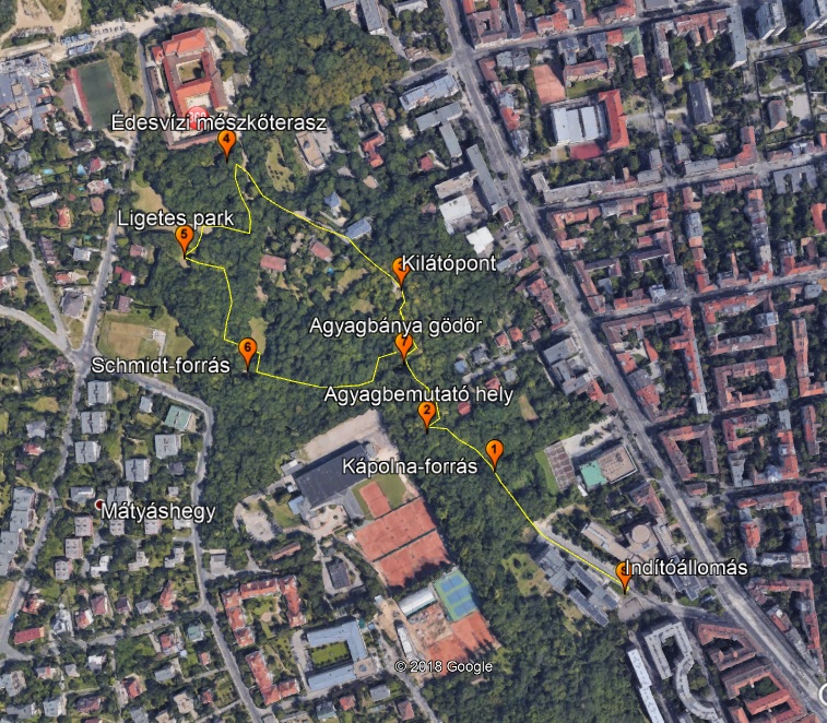
The stations are (in brackets the altitude of each site):
-
Chapel spring: the aim is to show the hydrographic values and culturally important monuments. (145 m)
-
Clay demonstration site: a description of the Kiscelli Clay Formation, characteristic of the area. (157 m)
-
Lookout spot: Besides the aesthetic values of the area, it is also an important site for the historical aspect. (152 m)
-
Freshwater limestone terrace: A rare natural treasure, a deposit of freshwater limestone that can be used as building material. (147m)
-
Glade Park: a station with botanical values, which also illustrates the current pioneer association. (155 m)
-
Schmidt spring: Another specimen from the springs of the Buda Hills, similar to its counterpart in terms of water yield. (150 m)
-
Clay mine pit: a site highlighting the mining importance of the area's past. (143 m)
The work of Ildikó Bocsi and her consultant, Dr. Judit Némethné Katona was a great help in the development of the trail. The current staff of the University of Óbuda created the Kiscelli-Doberdó educational path based on their previous work.
We wish you a pleasant and useful time on the tour!We wish you a pleasant and useful time on the tour!